Klickitat County
Evacation Plan DRAFT
The following content is a work in process and is provided here for easy access. The format will not reflect the finished document.
Section 1. Introduction & Signatures
Section 2. Purpose, Audience and Context
a. Purpose
This document is a primary directive for Incident Commanders (ICs), Emergency Management personnel, and Klickitat County Sheriff’s Office and other Law Enforcement supervisors responsible for executing evacuation orders. It serves as a tactical reference for Public Information Officers (PIOs) to ensure messaging consistency via the Emergency Notification System (ENS) and for Public Works and the Department of Transportation tasked with maintaining route integrity and gate closures.
Additionally, this plan provides necessary operational clarity for Mutual Aid partners and NGO support groups (e.g., Red Cross, livestock rescue) to ensure their deployment aligns with the County’s established incident objectives and safety zones.
b. Audience
The purpose of this plan is to establish a standardized operational framework for the mobilization, direction, and relocation of populations during high-threat incidents within Klickitat County. It defines the specific triggers for escalating evacuation levels and outlines the tactical coordination required between the Emergency Operations Center (EOC), on-scene Incident Command, and multi-jurisdictional support agencies.
By synchronizing traffic control, resource staging, and inter-agency communication, this plan ensures that evacuation routes remain viable and that life-safety priorities are executed with minimal friction under compressed timelines.
c. Context
Unlike routine disruptions, Klickitat County’s unique geography creates high-risk conditions that can rapidly compromise evacuation efforts. Our narrow canyon roads, imited bridge crossings over the Columbia, and the potential for reduced visibility from smoke or blowing dust can turn a standard exit into a life-threatening bottleneck.
Whether it is a Wildland-Urban Interface (WUI) fire, a post-fire debris flow, or a hazardous materials incident along our transportation corridors, threats can escalate in minutes. Because many homes and access routes are vulnerable to these diverse hazards, relying on "wait and see" is not a viable strategy. Early, informed action is the only way to ensure people's safety before routes are cut off.
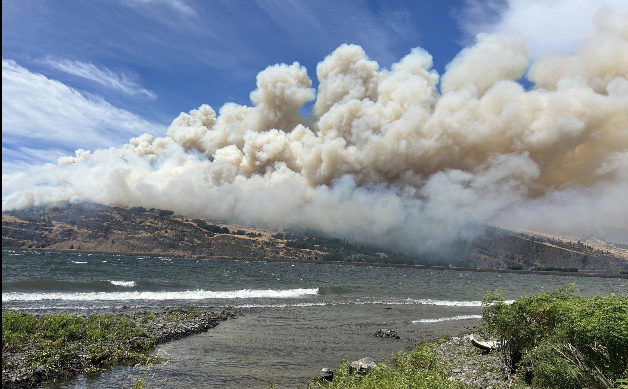
Wildland Urban Interface (WUI) Fires and Evacuations
Unlike other disasters, WUI fires create fast-moving, high-risk conditions that directly threaten evacuation efforts. Narrow roads, limited exits, and reduced visibility from smoke can quickly turn a "standard evacuation" into a life-threatening scenario. Even fires igniting outside of the community can impact your response, and most homes simply aren't built to withstand wildfire exposure, making early informed action critical.
WUI evacuations are extremely complex events; outcomes depend on community planning, fire ignition and spread, local weather, first responder activities, and evacuee decisions.
Initial Process
- Identification: Fire personnel or technical experts identify a specific threat to life and property.
- Recommendation: The Operations Section Chief or Incident Commander recommends a specific evacuation level to the Sheriff’s Office.
- Implementation: The Sheriff makes the final decision to issue the order. Sheriff’s deputies, often supported by Search and Rescue (SAR) or "posse" volunteers, perform door-to-door notifications.
- Notification: KCDEM triggers the Level 1 (Ready), Level 2 (Set), or Level 3 (Go) alerts through landlines and registered mobile devices.
Notice vs. No-Notice Evacuations
Notice Evacuations
- Definition: Evacuations where residents receive advance warning (hours to days).
- Examples:
- A large wildfire burning many miles away with a predictable path.
- Wildfire smoke forecasts indicate hazardous air quality approaching.
- Characteristics:
- Authorities have time to issue phased evacuation orders.
- Residents can prepare “go kits,” arrange transportation, and evacuate in an orderly way.
- Evacuation routes and shelters can be staffed and communicated in advance.
No-Notice Evacuations
- Definition: Evacuations triggered by sudden, immediate threats with little or no warning.
- Examples:
- A wind-driven wildfire spreading rapidly toward populated areas.
- Spot fires igniting near homes due to embers.
- A large spill or release as the result of a rail or truck incident.
- Characteristics:
- Authorities may only have minutes to issue an evacuation order.
- Residents must evacuate immediately, sometimes with little or no time to collect belongings.
- Evacuation messaging relies on pre-scripted alerts, local sirens, door-to-door warnings, and pre-established community awareness of “Ready, Set, Go” levels.
- Higher risk of congestion, confusion, and non-compliance due to urgency.
Evacuation Types or Phases
- Ready (Advisory / Level 1)
- Definition: Residents should prepare for potential evacuation. There is a credible threat, but immediate evacuation is not required.
- Actions:
- Monitor official information sources (local radio, social media, emergency alert systems).
- Prepare “go kits” with critical items (documents, medications, food, water).
- Identify and confirm evacuation routes and transportation needs.
- Prepare homes: move flammable materials away from structures, close windows/vents.
- Set (Warning / Level 2)
- Definition: Conditions exist that indicate a significant threat. Residents must be prepared to leave at short notice.
- Actions:
- Load essential belongings into vehicles.
- Practice loading family and pets into vehicles.
- Maintain situational awareness and be prepared to leave immediately if evacuation is ordered.
- Assist neighbors who may need support (elderly, disabled, or without transport).
- Go (Order / Level 3)
- Definition: The hazard poses an immediate threat to life and safety. Evacuation is essential.
- Actions:
- Leave immediately along designated evacuation routes.
- Do not delay gathering additional belongings.
- Follow instructions from law enforcement, fire officials, and incident management.
- Do not return until officials declare it safe.

d. Other Considerations
Shelter-in-Place In rare cases (e.g., fast-moving fire or hazardous smoke), officials may advise residents to stay inside a hardened or defensible structure rather than evacuate.
Phased / Zone Evacuation Used in larger communities where evacuation is ordered by zones to reduce congestion and improve traffic flow.
Self-Evacuation Residents may leave earlier than instructed if they feel unsafe, this is encouraged rather than waiting until conditions deteriorate.
Reentry Protocols Controlled return process after evacuation to ensure safety (checking for downed powerlines, hazardous debris, smoke conditions).
Temporary Fire Refuge Area A Temporary Fire Refuge Area (TFRA) is a pre-identified open space intended to offer reduced exposure to flames and heat when evacuation is no longer possible. Unlike safety zones or formal shelters, TFRAs are not guaranteed safe zones; they are intended only as a last resort. Communities should understand the differences between TFRAs, general TRAs, and safety zones, as well as when and how TFRAs can be used during a fire to save lives under extreme conditions.
Safety Zone A safety zone is a large open space that provides significant reduction in fire exposures such that the location is tenable without protective equipment. The term "safety zone," given its name, implies a certain degree of protection which may or may not be present in a TFRA. Conceptually, safety zones can be larger than TFRAs to provide "safety" or enhanced protection, however, there are currently no standards for TFRAs or safety zones.
WUI Resources
US Fire Administration: https://www.usfa.fema.gov/wui/outreach/ Ready-Set-Go: https://www.iafc.org/docs/default-source/pdf/rsg-eag.pdf?sfvrsn=d1316f0c_24 How to Prepare for a Wildfire: https://dnr.wa.gov/sites/default/files/2025-03/rp_fire_how_to_prepare_wildfire.pdfSection 3. Concept of Operations (Con-Ops)
a. Authorities & Roles
In Klickitat County, Washington, the primary legal and operational authority to initiate and implement evacuations lies with the Klickitat County Sheriff. While multiple agencies collaborate during a disaster, the division of responsibility is generally split between the recommendation (the fire/hazmat or law enforcement incident commanders) and the execution (the Sheriff).
| Entity | Primary Role in Evacuations |
|---|---|
| Klickitat County Sheriff | Legal Authority. The Sheriff is responsible for issuing official evacuation notices and managing the physical movement of people. Under Washington law, law enforcement is the agency charged with public safety and evacuation implementation. |
| Incident Commander (IC) | Technical Recommendation. During a disaster, the IC (from the fire department or a state/federal team) identifies the threat levels and formally requests that the Sheriff initiate evacuations based on risk (likelihood and consequence) of the threat or hazard impacting life safety. |
| Klickitat County Dept. of Emergency Management (KCDEM) | Coordination & Communication. KCDEM activates the Emergency Operations Center (EOC) and sends out the mass alerts (via the Emergency Notification System) once an evacuation is ordered. |
| Board of County Commissioners | Emergency Proclamation. The Chairman can declare a local State of Emergency, which provides the legal framework to support wide-scale emergency measures and resource requests. |
Important Legal Note: Under Washington State law, a Sheriff generally cannot forcibly remove a person from their own property due to a threat or hazard alone. However, they can
- Restrict Access: Close roads and prevent people from entering a dangerous area.
- Arrest for Other Violations: Forcibly remove individuals if they are obstructing fire or law enforcement operations, trespassing on others' property, or violating other standing laws.
| Hazard Type | Primary Monitoring Source | Warning Indicators |
|---|---|---|
| Wildfire | DNR / USFS / Central WA Interagency Dispatch | Red Flag Warnings, Lightning strikes, Smoke reports. |
| Flooding | National Weather Service (NWS) / NOAA | River gauges (White Salmon/Klickitat), Atmospheric Rivers. |
| Geologic | USGS / WA Dept. of Geology | Seismic activity (Mount St. Helens/Hood), Landslide risk. |
| Severe Weather | NWS Portland/Pendleton | High wind warnings (Gorge effect), Ice/Snow accumulations. |
b. Early Alert and Warning (Prepatory Phase)
1. Purpose To establish a standardized method for detecting, verifying, and disseminating early warnings to the public to maximize lead time for protective actions (evacuation or sheltering in place).
2. Hazard Detection & Monitoring Klickitat County monitors threat levels through continuous coordination with technical partners:
| Hazard Type | Primary Monitoring Source | Warning Indicators |
|---|---|---|
| Wildfire | DNR / USFS / Central WA Interagency Dispatch | Red Flag Warnings, Lightning strikes, Smoke reports. |
| Flooding | National Weather Service (NWS) / NOAA | River gauges (White Salmon/Klickitat), Atmospheric Rivers. |
| Geologic | USGS / WA Dept. of Geology | Seismic activity (Mount St. Helens/Hood), Landslide risk. |
| Severe Weather | NWS Portland/Pendleton | High wind warnings (Gorge effect), Ice/Snow accumulations. |
3. The "Alert Klickitat" System (Everbridge) The primary tool for rapid notification is the Alert Klickitat mass notification system.
- Opt-In/Opt-Out: While landlines are automatically opted-in via 911 data, the County actively promotes mobile/VOIP registration for residents in rural areas like High Prairie or Bickleton.
- Targeted Geo-Fencing: Warnings will be sent using "polygon" mapping to alert only those in the direct path of the hazard, reducing "alert fatigue" for the rest of the county.
4. Alert Levels and Standardized Terms To ensure clarity across all hazards, Klickitat County utilizes the Level 1-2-3 evacuation terminology:
- Level 1 (READY):Be Aware. A threat is in the area. Monitor local media and prepare your "Go Kit." Residents with pets or livestock should consider moving them now.
- Level 2 (SET):Be Prepared. There is a significant threat. This is the final warning before mandatory evacuation. You should be ready to leave at a moment's notice.
- Level 3 (GO!):Evacuate Now. Immediate danger. Do not delay to gather belongings. Emergency services may not be able to assist you if you stay.
5. Redundant Communication Channels To account for Klickitat County’s rugged terrain and "dead zones," a multi-layered approach is required:
- Wireless Emergency Alerts (WEA): "Amber Alert" style messages pushed to all cell phones in a specific area (no sign-up required
- Emergency Alert System (EAS): Digital interrupts on local television and radio
- High-Low Sirens: Sheriff’s Office vehicles and Fire apparatus using the "European style" siren to signal immediate evacuation in neighborhood
- Door-to-Door: Utilized in Level 2/3 scenarios if time permits, prioritized for "Access and Functional Needs" populations.
- Social Media: Real-time updates via the Klickitat County 911/EM Facebook and Sheriff’s Office pages.
6. Public Education (The "Blue Sky" Phase) The County will conduct annual "Pre-Season" outreach, including:
- Wildfire Awareness Month (May): Focusing on defensible space and "Go-Bag" preparation.
- Winter Weather/Flood Prep (October): Focusing on snow routes and river safety.
c. Decision & Initiation
d. Warning & Notification
e. Evacuation / TFRA / Shelter-in-Place
f. Sheltering (Appendix)
g. Reentry
1. Purpose and Scope The goal of this section is to provide a structured, safe, and orderly process for residents and business owners to return to evacuated areas. Reentry will only commence once the Incident Command (IC), in coordination with the Klickitat County Sheriff’s Office and Emergency Management, determines that the immediate threat has been mitigated.
2. Reentry Phases To manage traffic flow and ensure safety, reentry will often occur in three distinct phases:
| Phase | Category | Description |
|---|---|---|
| Phase 1 | Emergency Services | Utility repair crews (PUD), road departments, and assessment teams to secure infrastructure. |
| Phase 2 | Limited Access | Business owners and residents with specialized needs (e.g., livestock welfare) to assess damage. |
| Phase 3 | General Public | Full lifting of evacuation orders; the area is deemed safe for the general population. |
3. Safety Determination Criteria Before a "Go" decision is made, the following conditions must be met:
- Fire/Hazard Suppression: The threat is 100% contained or controlled near access routes.
- Infrastructure Integrity: Bridges, roads, and power lines must be inspected and cleared of debris or "hazard trees."
- Utility Restoration: Public Utility Districts (PUD) must confirm that downed lines are de-energized or repaired.
- Sanitation & Water: Confirmation that water systems are potable or "Boil Water" notices are ready for distribution.
4. Identification and Access Control Checkpoints may be established to prevent "looky-loos" and ensure security for damaged properties. Residents should be prepared to provide:
- A valid Driver’s License with a local address.
- A utility bill or property tax statement (if the DL address is not current).
- Business credentials (for Phase 2 entry).
5. Resident Safety Guidance Upon reentry, the County will provide residents with a "Safe Return" checklist, including:
- Structural Hazards: Warning against entering buildings with visible foundation cracks or roof damage.
- Food Safety: Instructions on disposing of spoiled food due to power outages.
- Ash & Debris: Guidance on the use of N95 masks when cleaning fire ash to avoid respiratory distress.
- Wildlife: Awareness that displaced wildlife (cougars, bears, or rattlesnakes) may have sought refuge in residential outbuildings.
6. Public Notification The transition from Level 3 (Go Now) to Level 1 (Ready) will be communicated via:
- Klickitat County Emergency Notification System (Everbridge).
- Official Social Media channels (Sheriff’s Office and Klickitat County 911).
- Local radio broadcasts (KLCK, KIHR).
Note to Staff: This draft assumes a wildfire-centric hazard but can be adapted for flooding or hazardous material spills. Coordination with the Klickitat PUD and Public Works is essential for Phase 1 timelines.
In Klickitat County, a major incident—especially a wildfire—often involves the U.S. Forest Service (USFS), Bureau of Land Management (BLM), and Washington Department of Natural Resources (DNR).
Because these agencies often operate under a Unified Command or through a Delegation of Authority (DOA), the decision to let people back in isn't made by the County in a vacuum; it’s a coordinated handshake between the people fighting the fire and the local authorities responsible for public safety.
h. Incident Management Team Engagement
1. Unified Command Structure Klickitat County utilizes the National Incident Management System (NIMS) to ensure seamless integration with state and federal partners. For incidents crossing jurisdictional boundaries (e.g., a fire moving from private land to the Gifford Pinchot National Forest), a Unified Command (UC) may be established.
- Decision Authority: While the Incident Management Team (IMT) provides the "Safe/Unsafe" assessment based on fire behavior, the Klickitat County Sheriff retains the legal authority to lift or modify evacuation orders for non-federal lands.
- Liaison Officers: A County Liaison will be embedded within the IMT to ensure that local reentry priorities (e.g., moving livestock, restoring PUD services) are integrated into the IMT’s operational planning.
2. State and Federal Partner Roles Reentry depends on the "Clearance to Proceed" from various stakeholders:
| Agency | Primary Responsibility in Reentry |
|---|---|
| WA Dept. of Natural Resources (DNR) | Confirms suppression of fire on state-protected lands and assesses "hazard trees" along state-managed corridors. |
| WA Dept. of Transportation (WSDOT) | Inspects and clears state routes (e.g., SR-14, US-97) of debris, rocks, or structural damage to guardrails and bridges. |
| U.S. Forest Service / BLM | Provides "Burned Area Emergency Response" (BAER) assessments to identify immediate post-fire threats like flash flooding or landslides. |
| WA State Patrol (WSP) | Assists local law enforcement with traffic control points and "escorted reentry" if localized hazards remain. |
3. The "Transfer of Command" Protocol As an incident de-escalates, the IMT will begin "timing out" and transferring control back to the local Type 3 or Type 4 organization.
- Final Briefing: Before the IMT departs, a formal briefing must occur where the IMT provides the County with a map of "unmitigated hazards" (e.g., persistent hot spots or unstable slopes) that must be communicated to returning residents.
- Documentation: All state/federal damage assessments (FEMA/SBA-ready) will be handed over to the Klickitat County Emergency Management Director to streamline the recovery and disaster declaration process.
4. Post-Fire Assessment Coordination For large-scale events, the County will request the activation of a Post-Fire Assessment Team through the State Emergency Management Division (EMD). This team coordinates with:
- Klickitat PUD: To ensure electrical infrastructure is safe before homeowners re-energize properties.
- County Health Department: To coordinate with state labs for testing private wells that may have been contaminated by fire retardant or high heat.